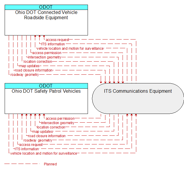
Interface: Ohio DOT Safety Patrol Vehicles - Ohio DOT Connected Vehicle Roadside Equipment
Architecture Flow Definitions
access permission (Planned) Applicable ITS Standards
Information returned indicating whether permission for access is granted and instructions for proceeding.
access request (Planned) Applicable ITS Standards
Request for access to an access–controlled transportation facility.
intersection geometry (Planned) Applicable ITS Standards
The physical geometry of an intersection covering the location and width of each approaching lane, egress lane, and valid paths between approaches and egresses. This flow also defines the location of stop lines, cross walks, specific traffic law restrictions for the intersection (e.g., turning movement restrictions), and other elements that support calculation of a safe and legal vehicle path through the intersection.
ITS information (Planned)
Information exchanged by ITS systems or devices. This flow is a super–flow; it does not define specific content since it represents any information flow exchange between physical objects defined in ARC–IT. This information flow represents any of those information flows and inherits the data content and attributes defined in the more detailed information flows.
location correction (Planned) Applicable ITS Standards
Information provided to improve positional accuracy. These corrections allow a mobile GPS receiver, such as a GPS system in a connected vehicle, to achieve a
greater absolute positional accuracy, compensating for errors that exist in satellite positioning.
map updates (Planned) Applicable ITS Standards
Map update which could include a new underlying static or real–time map or map layer(s) update.
road closure information (Planned) Applicable ITS Standards
Road closure information provided to passing vehicles. This flow provides information about the road closure with diversion information.
roadway geometry (Planned) Applicable ITS Standards
The physical geometry of a road segment that specifies the location and width of each lane, including normal lanes as well as special lanes for pedestrians and bicycles, transit vehicles, and trains. This flow also may include the curvature, grade, and superelevation or banking of the road segment.
vehicle location and motion for surveillance (Planned) Applicable ITS Standards
Data describing the vehicle's position, heading, speed, acceleration, transmission, steering wheel angle, braking status, size information, and trajectory. This flow represents monitoring of basic safety data ('vehicle location and motion') broadcast by passing connected vehicles for use in vehicle detection and traffic monitoring applications.