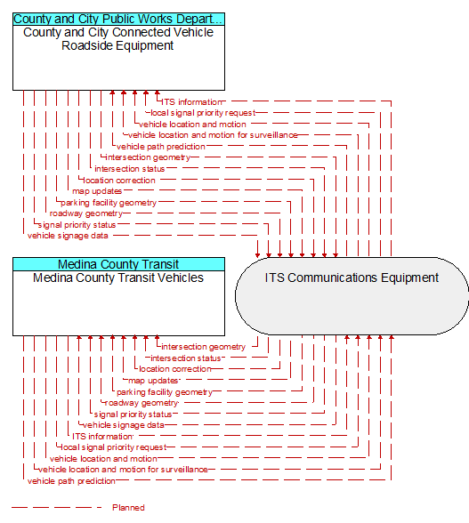
Interface: Medina County Transit Vehicles - County and City Connected Vehicle Roadside Equipment
Architecture Flow Definitions
intersection geometry (Planned) Applicable ITS Standards
The physical geometry of an intersection covering the location and width of each approaching lane, egress lane, and valid paths between approaches and egresses. This flow also defines the location of stop lines, cross walks, specific traffic law restrictions for the intersection (e.g., turning movement restrictions), and other elements that support calculation of a safe and legal vehicle path through the intersection.
intersection status (Planned) Applicable ITS Standards
Current signal phase and timing information for all lanes at a signalized intersection. This flow identifies active lanes and lanes that are being stopped and specifies the length of time that the current state will persist for each lane. It also identifies signal priority and preemption status and pedestrian crossing status information where applicable.
ITS information (Planned)
Information exchanged by ITS systems or devices. This flow is a super–flow; it does not define specific content since it represents any information flow exchange between physical objects defined in ARC–IT. This information flow represents any of those information flows and inherits the data content and attributes defined in the more detailed information flows.
local signal priority request (Planned) Applicable ITS Standards
Request from a vehicle to a signalized intersection for priority at that intersection. This flow also allows the vehicle to cancel a priority request (for example, when the vehicle clears the intersection).
location correction (Planned) Applicable ITS Standards
Information provided to improve positional accuracy. These corrections allow a mobile GPS receiver, such as a GPS system in a connected vehicle, to achieve a
greater absolute positional accuracy, compensating for errors that exist in satellite positioning.
map updates (Planned) Applicable ITS Standards
Map update which could include a new underlying static or real–time map or map layer(s) update.
parking facility geometry (Planned) Applicable ITS Standards
Precise spatial description of a parking facility that locates each parking space and the ingress and egress routes that are used to travel to and from the spaces.
roadway geometry (Planned) Applicable ITS Standards
The physical geometry of a road segment that specifies the location and width of each lane, including normal lanes as well as special lanes for pedestrians and bicycles, transit vehicles, and trains. This flow also may include the curvature, grade, and superelevation or banking of the road segment.
signal priority status (Planned) Applicable ITS Standards
In response to a request for signal priority, this flow indicates the status of the priority or preemption request.
vehicle location and motion (Planned) Applicable ITS Standards
Data describing the vehicle's position, heading, speed, acceleration, transmission, steering wheel angle, braking status, size information, and trajectory.
vehicle location and motion for surveillance (Planned) Applicable ITS Standards
Data describing the vehicle's position, heading, speed, acceleration, transmission, steering wheel angle, braking status, size information, and trajectory. This flow represents monitoring of basic safety data ('vehicle location and motion') broadcast by passing connected vehicles for use in vehicle detection and traffic monitoring applications.
vehicle path prediction (Planned) Applicable ITS Standards
The predicted future vehicle path of travel. This flow includes an indication of the future positions of the transmitting vehicle that can be used by receiving vehicles to support coordinated driving maneuvers and enhance in–lane and out–of–lane threat classification.
vehicle signage data (Planned) Applicable ITS Standards
In–vehicle signing data that augments regulatory, warning, and informational road signs and signals. The information provided would include static sign information (e.g., stop, curve warning, guide signs, service signs, and directional signs) and dynamic information (e.g., current signal states, grade crossing information, local traffic and road conditions, detours, advisories, and warnings).